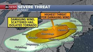
Severe thunderstorms may bring damaging winds from the Great Lakes to the Northeast on Sunday, with a more widespread threat in the Heartland early in the week. Sunday afternoon, strong to severe storms are expected to flare up along a cold front that will sweep across the Great Lakes and into the Northeast. Most of the action looks to be later in the afternoon and into the evening hours.
From Ohio to Connecticut — including nearly all of Pennsylvania — the Storm Prediction Center is watching the chance for severe thunderstorms.
Damaging winds remains the biggest concern, but small to moderate hail and an isolated tornado or two are also possible.
On Monday, the severe weather threat really ramps up in the Plains. Cities like Oklahoma City and Wichita, Kansas, are looking at an enhanced risk for widespread severe weather, mainly on Monday evening and into the overnight hours.
So far this year, severe weather reports are lagging slightly behind average, but the gap is closing after all the activity in the past week.
Tuesday brings another day of severe weather, with the focus shifting slightly eastward.
From Texas to Wisconsin, severe weather could cause trouble for millions in the Central U.S. Prior to storms firing up, temperatures will soar well above average across the western half of the country. This wave of warmth will stretch its way east over the weekend into early next week.
Daytime highs rising between 10 to 30 degrees above average — and possibly higher in some places — will impact a large swath of the nation over the next few days, with parts of the Plains seeing the biggest departures from normal.
Near record-high temperatures will be possible.
Cooler air will make its way back in over the Rockies Sunday into Monday, dragging temperatures back near and below average there.
Yet, conditions will remain unseasonably warm across the Central U.S. as the warm air spreads farther east, covering the eastern two-thirds of the country. Even though the Plains will still see the biggest departures Sunday into Monday, temperatures will still climb 10 to 15 degrees above normal across portions of the Mississippi River Valley through the Mid-Atlantic and the Carolinas. Temperatures will moderate a bit midweek, but will still remain on the warmer side of normal across the southern U.S., and east of the Mississippi River.


